
English EN
2310 944 433 Mon–Fri 09:00–16:00, Sat 10:00–15:00 Request call
Loading catalog…

Your wishlist is empty

Your comparison list is empty

Your cart is empty

SeaCell™ [QR-X12S] 2-Sim 4G/LTE 600Mbps [2 x Cat-6] Wi-Fi Router

SeaCell™ [QR-X11S] 2-Sim 4G/LTE 300Mbps [Cat-6] Wi-Fi Router & GPS Tracking unit

4G/LTE Network
802.11n Wi-Fi standard
9–30 V DC Power supply

Product features

  • Manufacturer: SEACELL

Additional products

ALFA Network APOE03 Passive PoE Injector 5–57V (up to 48W) – Fast Ethernet

Passive PoE injector that carries data + power to passive PoE devices over a single

€29.00
+ −
Stainless steel mounting bracket for SeaCell 5G/4G marine routers

Stainless steel mounting bracket for SeaCell 5G/4G marine routers Larger fixings made

€29.00
+ −
QR-X12S
In stock
€649.00
+ −
  • Fast dispatch
  • Secure payment
SeaCell Marine 4G Router Yacht 4G Router
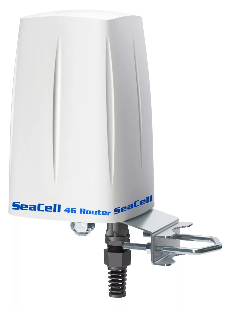
SeaCell™ QR-X12S
Dual-SIM 4G/LTE Router (2× LTE Cat 6) up to 600Mbps with a Load Balancing & Failover + Wi-Fi Router • with a built-in GPS/GSM Tracking System
SeaCell QR-X12S Marine Router
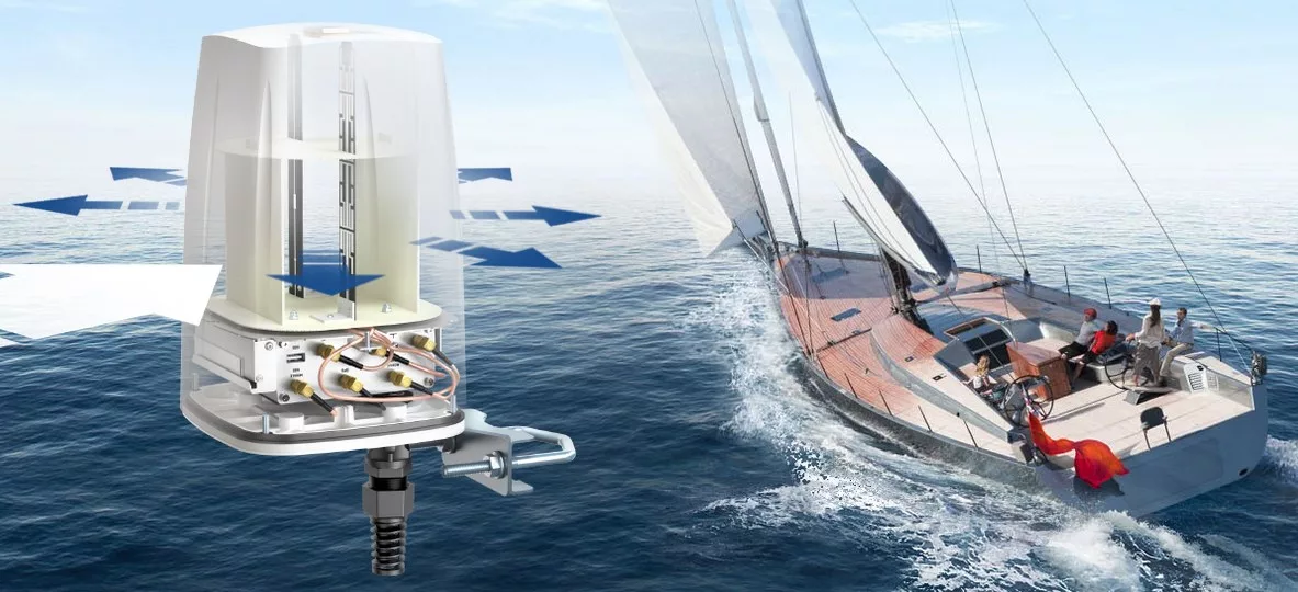
The need for immediate, high-quality communication, especially at sea, is a basic requirement for every boat. The SeaCell™ QR-X12S is an marine, all-in-one & compact system removes the external 4G/Wi-Fi antennas and the coaxial down-lead cables, reducing installation time, cost and – most importantly – minimising signal losses.
With 2× LTE Cat 6 and the ability to speed aggregation via Dual-SIM, reaching up to 600Mbps (depending on the network), while it offers Load Balancing and Failover for a more stable connection. At the same time, it has a built-in GPS/GSM Tracking System for tracking & fleet management of boats.
Dual-SIM (2× Cat 6) Up to 600Mbps Load Balancing Failover GPS Tracking Wi-Fi 802.11n UV Protected Dome Up to 50 devices
Range at sea up to 30 n.m. from the coast (depends on the installation height and "line of sight" to the antennas along the coast). In addition, when there is a known Wi-Fi network (e.g. a marina), it connects automatically to limit GSM charges.
Wi-Fi Network
Reliable Wi-Fi 802.11n up to 300Mbps, coverage up to 150m (depending on the environment) and simultaneous connection of up to 50 devices.
Internet Supply
Dual-SIM 4G with Load Balancing for better performance and Failover for stability. Automatic connection to an available known Wi-Fi network (e.g. a marina's) to limit charges.
Remote Management
Remote diagnosis, configuration and software upgrades, without a technician travelling to the boat.
Installation
All units are integrated into a UV-protected dome that is mounted at a high point on the boat, for greater range and better Wi-Fi diffusion. All that is required is a 9–30V DC power supply and 1 or 2 SIM cards.
SIM Card
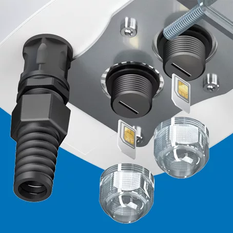
SIM card installation
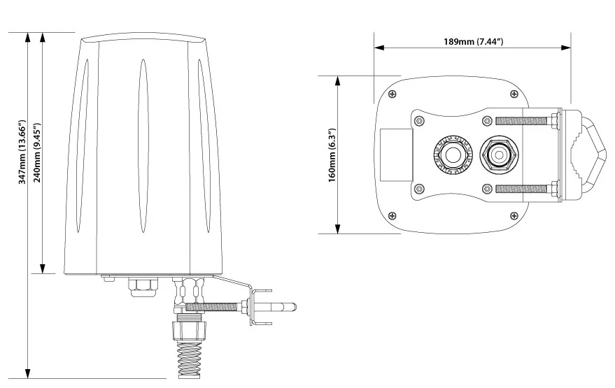
Dimensions
QR-X12S dimensions
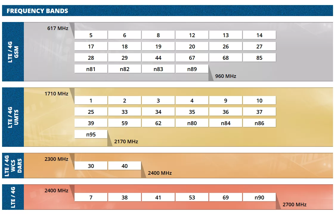
Supported frequency bands
Frequency bands
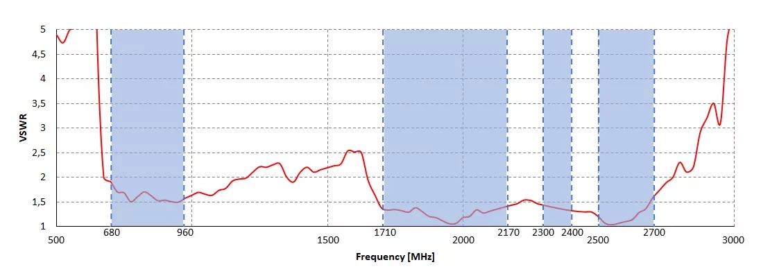
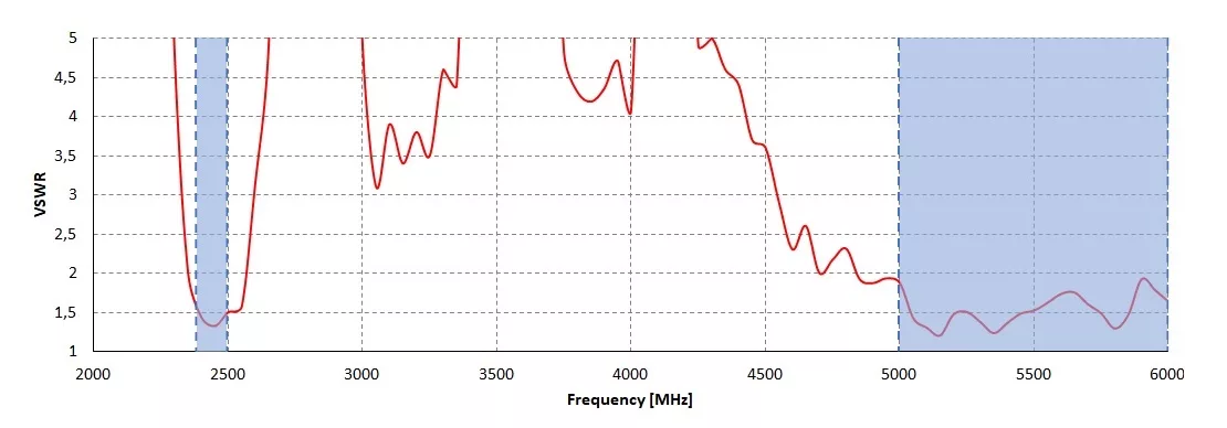
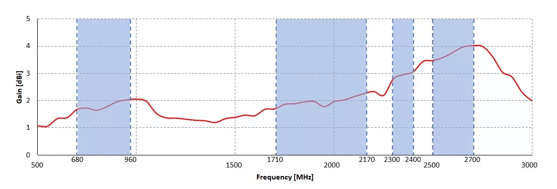
RF Charts (VSWR & Gain)
Charts presented uniformly in a single style.
VSWR for LTE antenna
VSWR for Wi-Fi antenna
Gain for LTE antenna
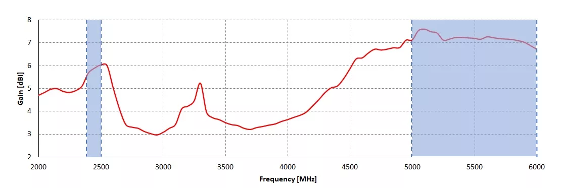
Gain for Wi-Fi antenna
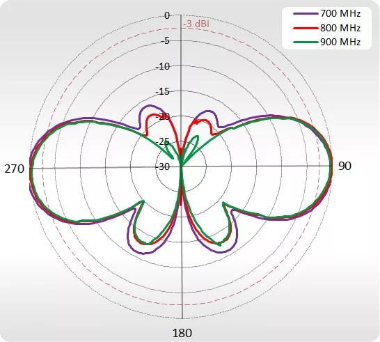
700–900 MHz Azimuth
700-900 MHz Azimuth
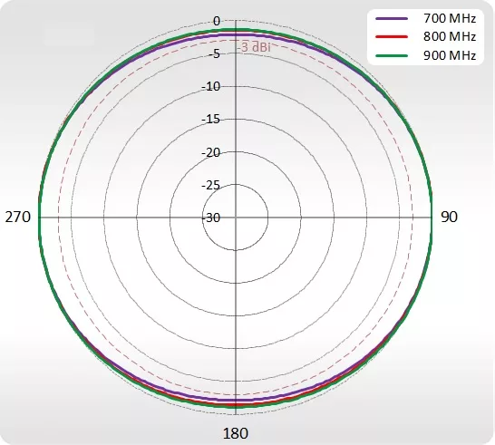
700–900 MHz Elevation
700-900 MHz Elevation
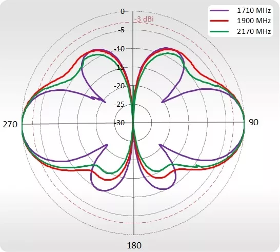
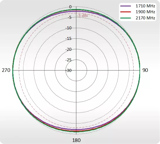
1710–2170 MHz Azimuth
1710-2170 MHz Azimuth
1710–2170 MHz Elevation
1710-2170 MHz Elevation
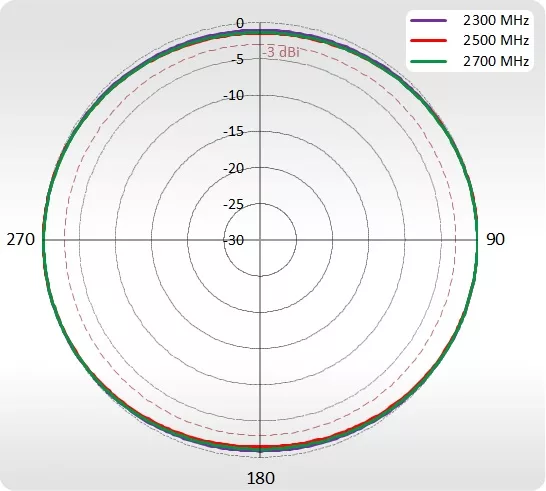
2300–2700 MHz Azimuth
2300-2700 MHz Azimuth
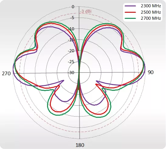
2300–2700 MHz Elevation
2300-2700 MHz Elevation
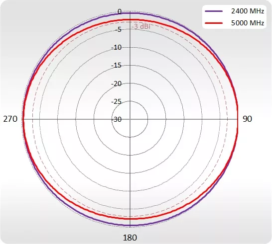
Wi-Fi Azimuth
Wi-Fi Azimuth
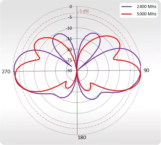
Wi-Fi Elevation
Wi-Fi Elevation
Capabilities of the tracking & boat-management unit (with a small annual subscription)
With the QR-X12S:
  1. You will always know where your boat is in real time.
  2. You will know in real time the speed it is moving at.
  3. You will know in real time whether it has stopped, where and for how long.
  4. You will know on a 24-hour basis all the routes and stops (Regatta / charter etc.).
  5. An automatic daily report by e-mail with a detailed itinerary (miles, stops, addresses).
  6. Monitor all boats simultaneously in real time.
  7. Real-time fuel monitoring (extra sensor).
  8. Engine-room temperature monitoring (extra sensor).
  9. Immediate alert when it enters/exits a specific area/point.
  10. Set geographic movement limits (geo-fence).
  11. Kilometres/miles per day, month and year.
  12. Route history per boat and playback in "Video" form.

Yachts positions
Note: The tracking/reporting functions require service activation (annual subscription).

Tracking on phone
Tεχνικά Χαρακτηριστικά:

  Parani-UD100
Standards
  • Bluetooth 4.0 Class 1
  • USB 2.0
Max Transfer Rate 3 Mbps (EDR)
Frequency Range 2.402 ~ 2.480GHz
Transmit Output Power +19dBm (+6dBm EDR) E.I.R.P
Receive Sensitivity
  • Basic 1Mbps: -88 dBm
  • EDR 2Mbps: -87dBm
  • EDR 3Mbps: -82dBm
Antenna Connector RP-SMA
Antenna Gain
  • Default Stub Antenna: 1 dBi
  • Optional Dipole Antennas: 3 dBi & 5 dBi
  • Optional Patch Antenna: 9 dBi
Working Distance
(In Open Field)
  • Stub antenna – Stub antenna: 300 m
  • Dipole (3 dBi) – Dipole (3 dBi) : 400 m
  • Dipole (5 dBi) – Dipole (5 dBi): 600 m
  • Patch antenna – Patch antenna: 1 km

* working distance can vary depending on install environment
Bluetooth stack software Latest Device Driver: BlueSoleil
Bluetooth Profiles DUN, FAX, SPP, HID, FTP, OPP, SDP, HCRP, LAN, OBEX FTP, OBEX OPP, OBEX BIP, BIP, AVRCP, A2DP, HSP, HFP, PAN, BPP, Headset, AVCTP, AVDTP, HDP, Find Me, Proximity, Health Thermometer, Heart Rate, HID OVER GATT
Computer OS Support
  • Windows XP/Vista/7/8 (32/64bit)
  • Linux (3rd party driver required)
  • MAC OS X (MAC OS X driver required)
Size 72(L) x 22(W) x 10(H) mm
Operating Temperature -40 ~ +85℃
Storage Temperature -40 ~ +85℃
Humidity 90% Non-condensing
Regulatory Approvals FCC, CE, TELEC, KCC, IC, Bluetooth SIG
Warranty 1 year Limited Warranty
Sort by:
5
Ενα πολύ καλό εργαλείο για επαγγελματικά σκάφη.
Αξιζει 100% τα χρηματα του.
0 0
Write a review